
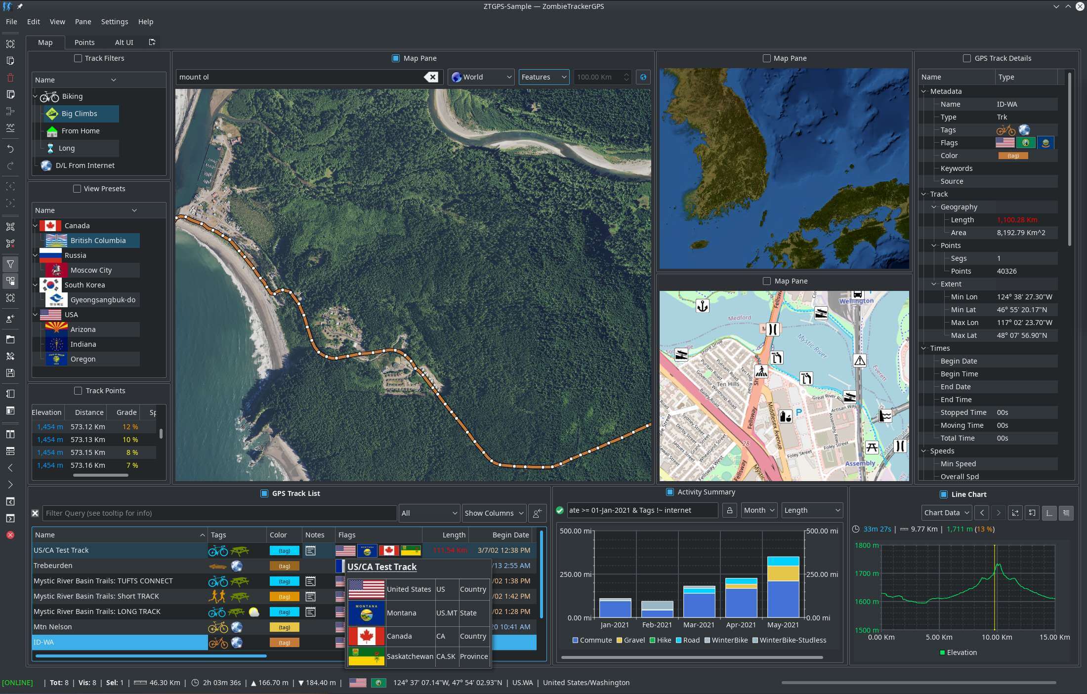
ZombieTrackerGPS (ZTGPS) can manage collections of GPS tracks from biking, hiking, rafting, light aircraft, snowboarding, and many other activities. It features local data storage, privacy-by-design with no data scraping or monetization, advanced sorting and query capabilities to let you see and manage your data, and a highly customizable interface to put you in control.
ZTGPS is written for the KDE desktop, but will work on other desktops if the KDE and Qt libraries are available.
This is free and open source software.
Key Features
- A highly customizable UI, with session save and restore.
- Import and export of GPS files in GPX, TCX, KML, and FIT formats.
- Sophisticated query facilities. For example: “Show me all the tracks tagged as ‘Hike’ which climb over 2500 ft”.
- Easy recall of custom queries.
- Automatic flag application to tracks for countries and sub-country regional (state, prefecture, province, etc.) flags.
- Time based activity summarizing over weeks, months, or years, displayed by activity.
- Large set of flag icons for geographic indicators.
- Estimation of power and calories expended based on other data (slopes, speeds, etc).
- Find and visualize major climbs and your climbing performance.
- Chart Charting and graphing to visually see elevation, speed, etc profiles.
- Area-based searches for max or min speed, elevation, power, etc.
- Custom data colorization.
- Undo for data and user interface changes.
- Interactive track and point editing features.
- Custom tag icons for many common outdoor activities.
- In-app documentation.
- Support for a wide variety of physical units.
- Live capture from GPSD supported devices.
- Support for multiple map providers.
- Cachable maps for off-line use.
- Automatic waypoint icon selection from US National Park Service icon set.
- Track de-duplication, in case of redundant data import.
- Proximity based geographic name searching.
- Scriptable, command line batch data conversions between supported GPS file formats.
- Training zone analysis, with track section visualization.
Website: www.zombietrackergps.net/ztgps
Support: GitLab Code Repository
Developer: Loopdawg Software
License: GNU General Public License v3.0
ZombieTrackerGPS is written in C++. Learn C++ with our recommended free books and free tutorials.
Related Software
| GPS Tools | |
|---|---|
| MOBAC | Create offline atlases for GPS handhelds and cell phone applications |
| GPXSee | GPS log file viewer and analyzer |
| Traccar | GPS Tracking Platform |
| gpsd | GPS service daemon |
| Viking | GPS data editor, analyzer and viewer |
| GPSBabel | GPS file conversion plus transfer to/from GPS units |
| GpsPrune | View, edit, and convert coordinate data from GPS systems |
| ZombieTrackerGPS | Fitness and GPS track manager designed for KDE |
| QMapShack | GPS mapping (GeoTiff and vector) and GPSr management |
| Navit | Car navigation system with routing engine |
| GPS Correlate | Correlates digital images with GPS data filling EXIF fields |
| Open Cache Manager | Easy to use program for managing your geocaches |
| Satellite | Displays GNSS information obtained from NMEA sources |
| OpenCPN | Ship-borne GUI navigation |
| Geotagging | Photography geotagging tool |
| FoxtrotGPS | GPS/GIS application designed for small screens |
| AAT Activity Tracker | Tracking sportive activities, with an emphasis on cycling |
Read our verdict in the software roundup.
 Explore our comprehensive directory of recommended free and open source software. Our carefully curated collection spans every major software category. Explore our comprehensive directory of recommended free and open source software. Our carefully curated collection spans every major software category.This directory is part of our ongoing series of informative articles for Linux enthusiasts. It features hundreds of detailed reviews, along with open source alternatives to proprietary solutions from major corporations such as Google, Microsoft, Apple, Adobe, IBM, Cisco, Oracle, and Autodesk. You’ll also find interesting projects to try, hardware coverage, free programming books and tutorials, and much more. Discovered a useful open source Linux program that we haven’t covered yet? Let us know by completing this form. |