

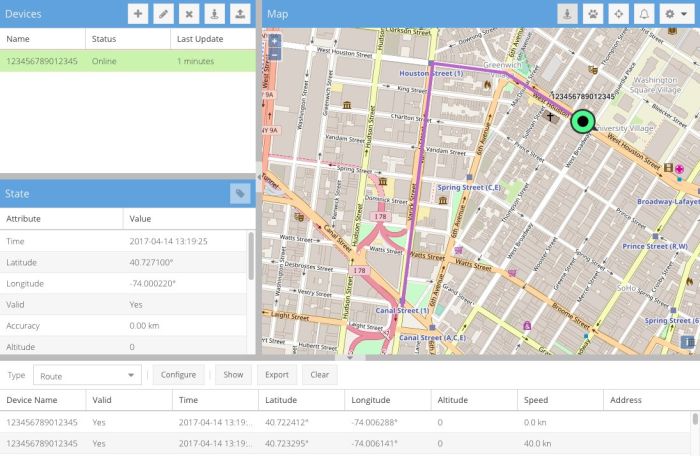
Traccar is a GPS tracking platform for monitoring vehicles, equipment, people and other assets. It consists of a Java-based server together with a browser interface and companion applications, and can be deployed on infrastructure controlled by the user.
A major strength is hardware compatibility. Traccar understands more than 200 tracking protocols and thousands of device models, ranging from inexpensive personal trackers to professional fleet hardware. Location data is stored in a SQL database and can be accessed through the web interface or integrated into other systems through its REST API.
This is free and open source software.
Key Features
- Real-time display of GPS devices and their reported position, movement and sensor information.
- Supports more than 200 GPS tracking protocols and thousands of tracker models.
- Web dashboard designed for both desktop and mobile displays.
- Location history with trip, route, stop, event, chart and summary reporting.
- Geofences can trigger events when tracked objects enter or leave defined geographical areas.
- Supports alarms and notifications through the web interface, email and SMS.
- Driver behaviour monitoring includes data such as speeding, harsh events and other reported device attributes.
- Account, group, user, device, driver and maintenance management.
- Computed attributes can derive or alter values reported by tracking devices using expressions.
- Supports calendars for applying schedules to features such as geofences and notifications.
- Works with major SQL database systems and exposes a REST API for external applications.
- Can send supported commands back to compatible tracking devices.
- Cross-platform support – runs on Linux and Windows.
Website: www.traccar.org
Support:
Developer: Traccar Ltd
License: Apache License 2.0
Traccar is written in Java. Learn Java with our recommended free books and free tutorials.
Related Software
| GPS Tools | |
|---|---|
| MOBAC | Create offline atlases for GPS handhelds and cell phone applications |
| GPXSee | GPS log file viewer and analyzer |
| Traccar | GPS Tracking Platform |
| gpsd | GPS service daemon |
| Viking | GPS data editor, analyzer and viewer |
| GPSBabel | GPS file conversion plus transfer to/from GPS units |
| GpsPrune | View, edit, and convert coordinate data from GPS systems |
| ZombieTrackerGPS | Fitness and GPS track manager designed for KDE |
| QMapShack | GPS mapping (GeoTiff and vector) and GPSr management |
| Navit | Car navigation system with routing engine |
| GPS Correlate | Correlates digital images with GPS data filling EXIF fields |
| Satellite | Displays GNSS information obtained from NMEA sources |
| PyGPSClient | Graphical tool for GNSS receiver testing, diagnostics and configuration |
| OpenCPN | Ship-borne GUI navigation |
| gpx.studio | GPX editor for creating, modifying and planning GPS routes |
| Geotagging | Photography geotagging tool |
| AAT Activity Tracker | Tracking sportive activities, with an emphasis on cycling |
Read our verdict in the software roundup.
 LinuxLinks helps you discover the best free and open source software for Linux. Explore our extensive collection of recommended applications, including alternatives to popular proprietary software. We also publish software reviews, Linux tutorials, hardware reviews, free programming books and articles covering the wider open source community. Browse our Linux resources to discover more. Know a useful free and open source Linux application we haven't covered? Suggest a program for inclusion. Has your software been featured on LinuxLinks? Display one of our Featured on LinuxLinks badges on your website or GitHub README. |
Please read our Comment Policy before commenting.