

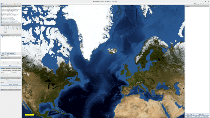
Mobile Atlas Creator, usually known as MOBAC, builds offline atlases from map tiles and other supported map sources. It is useful when a navigation application or GPS device needs map data in advance, particularly for travelling in areas where a network connection is unavailable, unreliable or expensive.
The user selects geographical areas, map sources and zoom levels and combines them into an atlas. MOBAC then downloads the required map material and packages it in a format suitable for the chosen application or device. Atlas profiles can be saved and reused when the same map collection needs to be rebuilt later.
This is free and open source software.
Key Features
- Downloads map tiles from supported online sources and stores them for offline use.
- Creates atlases for a variety of navigation applications and GPS devices.
- Supports custom XML map sources for services not included by default.
- Can work with WMS sources and locally available Mapsforge maps.
- Atlas projects may contain multiple layers, map sources and zoom levels.
- Saved atlas profiles make complex collections easy to rebuild or modify.
- Supports common output formats used by applications such as OsmAnd, OruxMaps, Garmin tools, TwoNav and OziExplorer.
- Can produce map tiles in several image formats and colour depths, including transparency where supported.
- Uses a local tile cache to avoid repeatedly downloading unchanged map data.
- Downloads map tiles concurrently to improve performance when building large atlases.
- Supports MBTiles-based workflows and map sources using different tile dimensions.
- Includes proxy support for network environments that require an HTTP proxy.
- Cross-platform support – runs on Linux, macOS, and Windows.
Website: mobac.sourceforge.io
Support:
Developer: r_x and contributors
License: GNU General Public License v2.0
MOBAC is written in Java. Learn Java with our recommended free books and free tutorials.
Related Software
| GPS Tools | |
|---|---|
| MOBAC | Create offline atlases for GPS handhelds and cell phone applications |
| GPXSee | GPS log file viewer and analyzer |
| Traccar | GPS Tracking Platform |
| gpsd | GPS service daemon |
| Viking | GPS data editor, analyzer and viewer |
| GPSBabel | GPS file conversion plus transfer to/from GPS units |
| GpsPrune | View, edit, and convert coordinate data from GPS systems |
| ZombieTrackerGPS | Fitness and GPS track manager designed for KDE |
| QMapShack | GPS mapping (GeoTiff and vector) and GPSr management |
| Navit | Car navigation system with routing engine |
| GPS Correlate | Correlates digital images with GPS data filling EXIF fields |
| Satellite | Displays GNSS information obtained from NMEA sources |
| PyGPSClient | Graphical tool for GNSS receiver testing, diagnostics and configuration |
| OpenCPN | Ship-borne GUI navigation |
| gpx.studio | GPX editor for creating, modifying and planning GPS routes |
| Geotagging | Photography geotagging tool |
| AAT Activity Tracker | Tracking sportive activities, with an emphasis on cycling |
Read our verdict in the software roundup.
 LinuxLinks helps you discover the best free and open source software for Linux. Explore our extensive collection of recommended applications, including alternatives to popular proprietary software. We also publish software reviews, Linux tutorials, hardware reviews, free programming books and articles covering the wider open source community. Browse our Linux resources to discover more. Know a useful free and open source Linux application we haven't covered? Suggest a program for inclusion. Has your software been featured on LinuxLinks? Display one of our Featured on LinuxLinks badges on your website or GitHub README. |
Please read our Comment Policy before commenting.