

QMapShack provides a versatile open source tool for GPS maps in GeoTiff format as well as Garmin’s img vector map format.
You can also view and edit your GPX tracks.
The application can import, view, edit GPS data in various file formats including GPX.
QMapShack is the successor of QLandkarteGT, a powerful GIS application that displays GPS data on a variety of maps, plan routes, explore the terrain, track object movement and more.
Key Features
- Maps:
- Easy and flexible use of vector, raster, and online maps. It’s designed for tourists, campers, and other outdoor enthusiasts who use a GPS device.
- Use several maps on a workspace.
- Garmin vector maps and *.jnx raster maps. Support for external TYP files.
- Raster maps supported by GDAL.
- Online maps (TMS and WTMS (partially)).
- Display multiple maps in one view.
- Reproject maps on-the-fly to view’s projection.
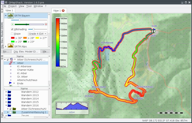
- Digital elevation model independent from maps.
- Hillshading and slope coloring.
- GIS Data:
- 100% project oriented data handling.
- Summarize project by a diary.
- Support for tracks, waypoints and areas.
- Simple geocache support.
- Store projects in a database.
- Support for multiple databases.
- Planning:
- Undo/redo history for all items.
- Track point edit mode to create/change tracks.
- Cut/copy/combine/reverse tracks.
- Various filter to enhance tracks.
- GPS Devices:
- Support for newer Garmin devices.
- Support for TwoNav devices.
- Project oriented data organization on devices.
- Synchronize your project with several devices attached.
- Supports data exchange with several GPS outdoor units.
- Full screen mode.
- Functionality to search the database or filter the workspace items by searching for a text in the items full text information.
- Internationalization support – Czech, French, German, Russian, and Spanish.
- Cross platform support. There are also binaries for Windows and Mac OS X operating systems.
Website: github.com/Maproom/qmapshack
Support: Quickstart, Forum (in German)
Developer: Oliver Eichler
License: GNU General Public License v3.0
QMapShack is written in C++. Learn C++ with our recommended free books and free tutorials.
Related Software
| GPS Tools | |
|---|---|
| MOBAC | Create offline atlases for GPS handhelds and cell phone applications |
| GPXSee | GPS log file viewer and analyzer |
| Traccar | GPS Tracking Platform |
| gpsd | GPS service daemon |
| Viking | GPS data editor, analyzer and viewer |
| GPSBabel | GPS file conversion plus transfer to/from GPS units |
| GpsPrune | View, edit, and convert coordinate data from GPS systems |
| ZombieTrackerGPS | Fitness and GPS track manager designed for KDE |
| QMapShack | GPS mapping (GeoTiff and vector) and GPSr management |
| Navit | Car navigation system with routing engine |
| GPS Correlate | Correlates digital images with GPS data filling EXIF fields |
| Open Cache Manager | Easy to use program for managing your geocaches |
| Satellite | Displays GNSS information obtained from NMEA sources |
| OpenCPN | Ship-borne GUI navigation |
| Geotagging | Photography geotagging tool |
| FoxtrotGPS | GPS/GIS application designed for small screens |
| AAT Activity Tracker | Tracking sportive activities, with an emphasis on cycling |
Read our verdict in the software roundup.
 Explore our carefully curated directory of recommended free and open source software, covering every major software category. Explore our carefully curated directory of recommended free and open source software, covering every major software category.The directory forms part of our extensive collection of articles for Linux enthusiasts. It includes hundreds of detailed reviews, together with free and open source alternatives to proprietary software from companies such as Google, Microsoft, Apple, Adobe, IBM, Cisco, Oracle, and Autodesk. LinuxLinks also covers interesting projects worth exploring, Linux-compatible hardware, free programming books and tutorials, and much more. Know a useful free and open source Linux application that we haven’t covered? Tell us about it using our submission form. |
Please read our Comment Policy before commenting.