

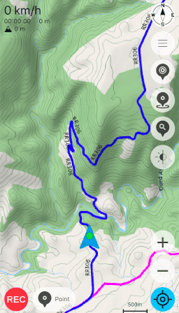
osmin is a GPS navigator for on-road and off-road use on Android and Unix-like desktop systems.
It is built around OpenStreetMap data and a fork of libosmscout, and is aimed at people who want a locally controlled mapping application rather than a service tied to a proprietary online platform. The project takes inspiration from osmscout/Karry and uses Qt 6 with a modern C++20 codebase.
On desktop systems it maintains a dedicated osmin directory beneath the user’s home directory for configuration, downloaded resources and other persistent data. Linux and BSD are supported build and test environments, while Android packages target ARM devices. This combination makes it particularly relevant for walkers, cyclists and drivers who prefer open mapping data and self-contained navigation tools.
This is free and open source software.
Key Features
- Downloads map data so mapping remains available without a permanent network connection.
- Calculates road routes between selected locations.
- Provides a generic compass for orientation when travelling away from established roads.
- Includes a tracker for recording movement during a journey.
- Reads existing GPX files and writes recorded data back to GPX.
- Provides a point-of-interest database for finding mapped places and facilities.
- Includes a simulator binary that can be run from the desktop build tree for development and testing.
- Uses OpenMP alongside its C++ implementation.
- Draws on Qt modules for positioning, multimedia, sensors, SVG rendering and text-to-speech integration.
Website: github.com/janbar/osmin
Support:
Developer: janbar
License: GNU General Public License v3.0
osmin is written in C++. Learn C++ with our recommended free books and free tutorials.
Related Software
| Mapping Tools | |
|---|---|
| Organic Maps | Offline maps & GPS app for hiking, cycling, biking, and driving |
| CoMaps | Community-led maps and navigation application |
| QGIS | GIS that supports vector, raster, and database formats |
| Marble | Virtual globe and world atlas |
| Placemark | Web-based tool for geospatial data |
| JOSM | Extensible editor for OpenStreetMap |
| uMap | Web application for creating and publishing custom interactive maps |
| Map | Wardley map editor |
| Kadas Albireo | Mapping application based on QGIS targeted at non-specialized users |
| TuiView | Lightweight raster GIS |
| Pure Maps | Native map and navigation application |
| Merkaartor | OpenStreetMap mapping program |
| GNOME Maps | Find places around the world |
| VersaTiles | Generate, process, store, serve, and render map tiles |
Read our verdict in the software roundup.
 Explore our carefully curated directory of recommended free and open source software, covering every major software category. Explore our carefully curated directory of recommended free and open source software, covering every major software category.The directory forms part of our extensive collection of articles for Linux enthusiasts. It includes hundreds of detailed reviews, together with free and open source alternatives to proprietary software from companies such as Google, Microsoft, Apple, Adobe, IBM, Cisco, Oracle, and Autodesk. LinuxLinks also covers interesting projects worth exploring, Linux-compatible hardware, free programming books and tutorials, and much more. Know a useful free and open source Linux application that we haven’t covered? Tell us about it using our submission form. |
Please read our Comment Policy before commenting.