

One of Google’s most popular services is Google Maps, a web mapping service which offers satellite imagery, aerial photography, street maps, and interactive panoramic views. While it’s a very easy mapping service to use, it collects a lot of data which isn’t limited to GPS location settings from your phone.
This roundup includes software which offers quick access to maps all across the world. The software lets you find the place you’re looking for by searching for a city or street, or locate a place to meet a friend. Some of the software uses the OpenStreetMap database, a collaborative project to create a free editable map of the world. OpenStreetMap allows you to view, edit and use geographical data in a collaborative way from anywhere on Earth. It’s kept up to date by people using GPS devices, aerial photography and other free sources of information.
This roundup includes some specialised tools.
Here’s our verdict captured in a legendary LinuxLinks-style ratings chart. Only free and open source software is eligible for inclusion here.
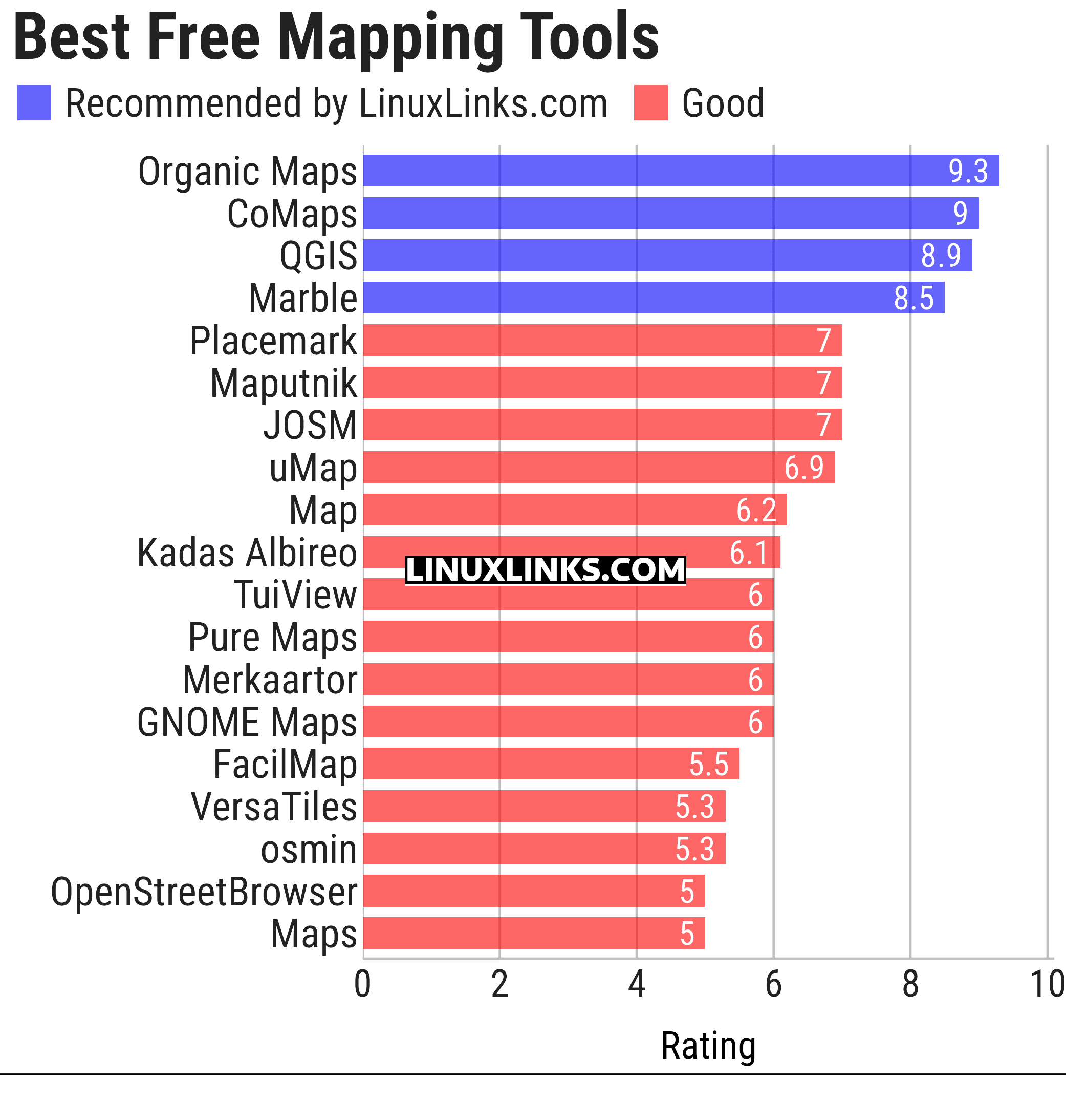
Click the links in the table below to learn all about each program.
| Mapping Tools | |
|---|---|
| Organic Maps | Offline maps & GPS app for hiking, cycling, biking, and driving |
| CoMaps | Community-led maps and navigation application |
| QGIS | GIS that supports vector, raster, and database formats |
| Marble | Virtual globe and world atlas |
| Placemark | Web-based tool for geospatial data |
| Maputnik | Visual editor for creating and editing MapLibre map styles |
| JOSM | Extensible editor for OpenStreetMap |
| uMap | Web application for creating and publishing custom interactive maps |
| Map | Wardley map editor |
| Kadas Albireo | Mapping application based on QGIS targeted at non-specialized users |
| TuiView | Lightweight raster GIS |
| Pure Maps | Native map and navigation application |
| Merkaartor | OpenStreetMap mapping program |
| GNOME Maps | Find places around the world |
| FacilMap | Collaborative map for planning and sharing locations |
| VersaTiles | Generate, process, store, serve, and render map tiles |
| osmin | GPS navigator for on-road and off-road navigation |
| OpenStreetBrowser | Browse and explore OpenStreetMap data by category |
| Maps | Lightweight map viewer for exploring places and locations |
This article has been updated to reflect the changes outlined in our recent announcement.
 LinuxLinks helps you discover the best free and open source software for Linux. Explore our extensive collection of recommended applications, including alternatives to popular proprietary software. We also publish software reviews, Linux tutorials, hardware reviews, free programming books and articles covering the wider open source community. Browse our Linux resources to discover more. Know a useful free and open source Linux application we haven't covered? Suggest a program for inclusion. Has your software been featured on LinuxLinks? Display one of our Featured on LinuxLinks badges on your website or GitHub README. |
Please read our Comment Policy before commenting.