

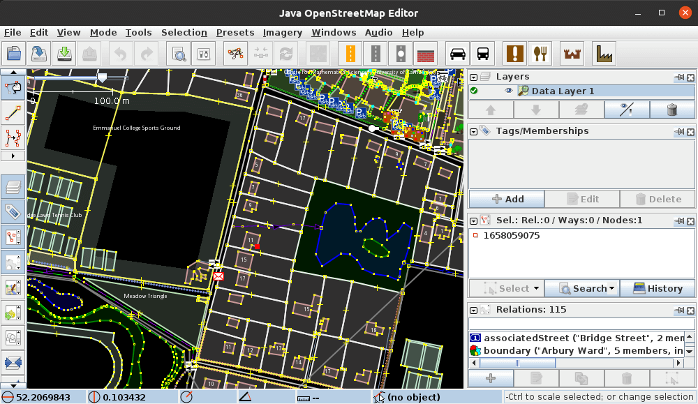
JOSM is a desktop editor for OpenStreetMap data aimed at users who need more control than is available from a simple browser-based editor. It supports detailed work on map geometry and tags, and is particularly well suited to larger editing sessions, specialised mapping tasks and workflows that use external imagery or GPS data.
The application is written in Java and can work with downloaded map data away from an active network connection. Its interface is highly configurable and can be extended with plugins, presets and custom map-paint styles.
This is free and open source software.
Key Features
- Edits OpenStreetMap nodes, ways, relations and their tags with detailed control over geometry and metadata.
- Loads GPX tracks and supports multiple data, imagery and marker layers.
- Uses background imagery from sources exposed through protocols such as WMS, TMS and WMTS.
- Includes a comprehensive validator that detects many common mapping errors and can automatically fix selected problems.
- Supports tagging presets that provide structured forms for frequently mapped object types.
- Provides data filters for hiding, disabling or isolating objects while working on complex datasets.
- Supports relations editing and tools for working with advanced OpenStreetMap data structures.
- Can download OSM data for editing and upload completed changesets back to OpenStreetMap.
- Supports offline editing after the required map data has been downloaded.
- Provides configurable rendering styles, keyboard shortcuts, toolbars and map projections.
- Offers an extensive plugin system for adding specialist editing, imagery, validation and import/export capabilities.
- Cross-platform support – runs on Linux and other operating systems with a suitable Java runtime.
Website: josm.openstreetmap.de
Support:
Developer: Dirk Stöcker and other contributors
License: GNU General Public License v2.0
JOSM is written in Java. Learn Java with our recommended free books and free tutorials.
Related Software
| Mapping Tools | |
|---|---|
| Organic Maps | Offline maps & GPS app for hiking, cycling, biking, and driving |
| CoMaps | Community-led maps and navigation application |
| QGIS | GIS that supports vector, raster, and database formats |
| Marble | Virtual globe and world atlas |
| Placemark | Web-based tool for geospatial data |
| Maputnik | Visual editor for creating and editing MapLibre map styles |
| JOSM | Extensible editor for OpenStreetMap |
| uMap | Web application for creating and publishing custom interactive maps |
| Map | Wardley map editor |
| Kadas Albireo | Mapping application based on QGIS targeted at non-specialized users |
| TuiView | Lightweight raster GIS |
| Pure Maps | Native map and navigation application |
| Merkaartor | OpenStreetMap mapping program |
| GNOME Maps | Find places around the world |
| FacilMap | Collaborative map for planning and sharing locations |
| VersaTiles | Generate, process, store, serve, and render map tiles |
| osmin | GPS navigator for on-road and off-road navigation |
| OpenStreetBrowser | Browse and explore OpenStreetMap data by category |
| Maps | Lightweight map viewer for exploring places and locations |
Read our verdict in the software roundup.
 LinuxLinks helps you discover the best free and open source software for Linux. Explore our extensive collection of recommended applications, including alternatives to popular proprietary software. We also publish software reviews, Linux tutorials, hardware reviews, free programming books and articles covering the wider open source community. Browse our Linux resources to discover more. Know a useful free and open source Linux application we haven't covered? Suggest a program for inclusion. Has your software been featured on LinuxLinks? Display one of our Featured on LinuxLinks badges on your website or GitHub README. |
Please read our Comment Policy before commenting.