

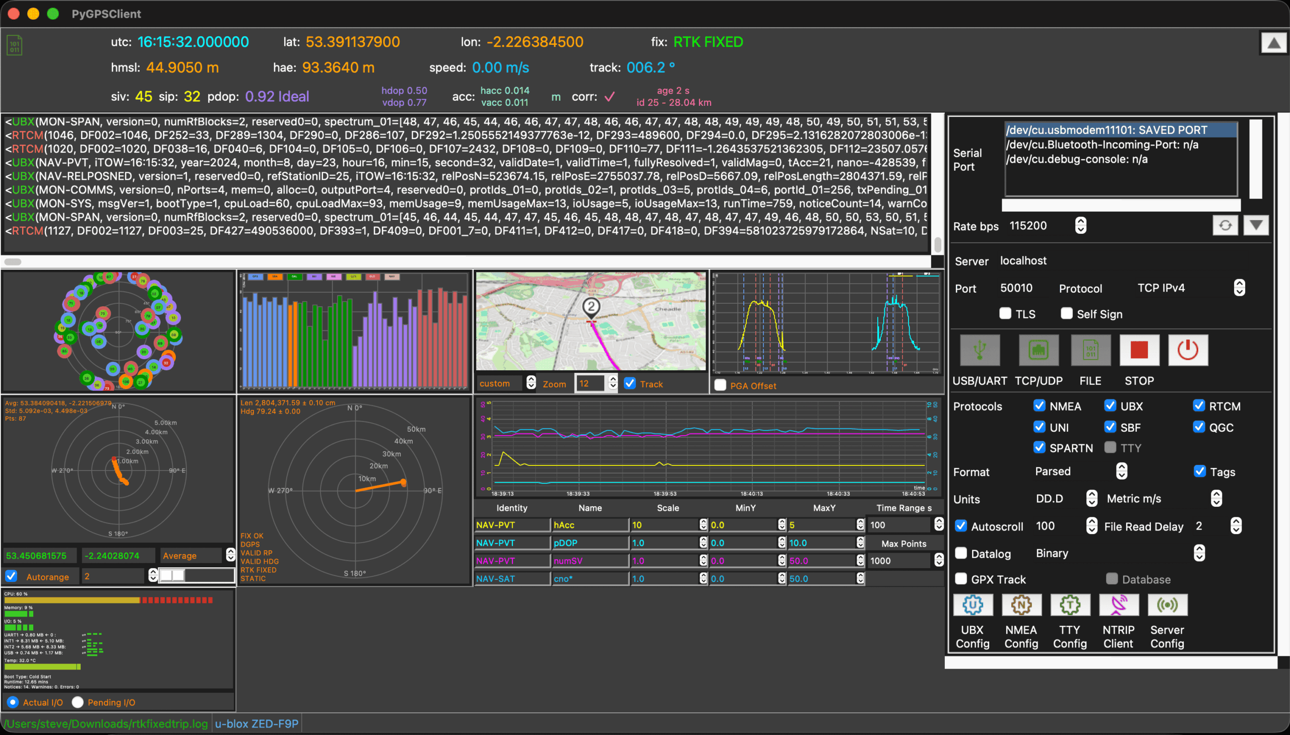
PyGPSClient is a graphical GNSS/GPS testing, diagnostic and configuration application for Linux and other platforms. It is aimed at users who need to work directly with GNSS receivers rather than simply display a position on a map.
The application can connect to physical receivers, network sources and previously recorded data streams, providing a central interface for examining receiver output and configuring supported hardware. This makes it useful for experimenting with GNSS equipment, diagnosing receiver behaviour, working with high-precision positioning and analysing recorded data. Its tkinter interface combines receiver information, satellite data, maps, console output and configuration controls.
This is free and open source software.
Key Features
- Supports NMEA, UBX, SBF, UNI, QGC, RTCM3, SPARTN, NTRIP and ASCII TTY protocols.
- Provides an NTRIP client for receiving RTCM3 and SPARTN correction data.
- Can operate as an NTRIP base station with compatible RTK receivers.
- Configures supported u-blox, Quectel, Septentrio, Unicore and Feyman GNSS devices.
- Displays console data in parsed, binary, hexadecimal and combined formats.
- Records GNSS data to timestamped log files.
- Records position data as GPX tracks.
- Includes a GPX track viewer.
- Provides experimental conversion of raw observation, navigation and meteorological data to RINEX.
- Supports decimal degrees, degrees/minutes/seconds, degrees/decimal minutes and ECEF position formats.
- Offers metric, imperial and maritime measurement units.
- Saves and restores application configuration settings.
- Supports user-defined receiver configuration presets.
- Can process previously captured binary GNSS data.
Website: github.com/semuconsulting/PyGPSClient
Support:
Developer: Steve Smith
License: BSD 3-Clause License
PyGPSClient is written in Python. Learn Python with our recommended free books and free tutorials.
Related Software
| GPS Tools | |
|---|---|
| MOBAC | Create offline atlases for GPS handhelds and cell phone applications |
| GPXSee | GPS log file viewer and analyzer |
| Traccar | GPS Tracking Platform |
| gpsd | GPS service daemon |
| Viking | GPS data editor, analyzer and viewer |
| GPSBabel | GPS file conversion plus transfer to/from GPS units |
| GpsPrune | View, edit, and convert coordinate data from GPS systems |
| ZombieTrackerGPS | Fitness and GPS track manager designed for KDE |
| QMapShack | GPS mapping (GeoTiff and vector) and GPSr management |
| Navit | Car navigation system with routing engine |
| GPS Correlate | Correlates digital images with GPS data filling EXIF fields |
| Open Cache Manager | Easy to use program for managing your geocaches |
| Satellite | Displays GNSS information obtained from NMEA sources |
| OpenCPN | Ship-borne GUI navigation |
| Geotagging | Photography geotagging tool |
| FoxtrotGPS | GPS/GIS application designed for small screens |
| AAT Activity Tracker | Tracking sportive activities, with an emphasis on cycling |
Read our verdict in the software roundup.
 Explore our carefully curated directory of recommended free and open source software, covering every major software category. Explore our carefully curated directory of recommended free and open source software, covering every major software category.The directory forms part of our extensive collection of articles for Linux enthusiasts. It includes hundreds of detailed reviews, together with free and open source alternatives to proprietary software from companies such as Google, Microsoft, Apple, Adobe, IBM, Cisco, Oracle, and Autodesk. LinuxLinks also covers interesting projects worth exploring, Linux-compatible hardware, free programming books and tutorials, and much more. Know a useful free and open source Linux application that we haven’t covered? Tell us about it using our submission form. |
Please read our Comment Policy before commenting.