

Geographic Resources Analysis Support System (GRASS) is an open source Geographic Information System (GIS) used for geospatial data management and analysis, image processing, graphics/maps production, spatial modeling, and visualization.
It consists of more than 400 modules for processing vector (2D/3D), raster and voxel data. Many interfaces to other programs in related domains like geostatistics, databases, mapserver and even other GIS software exist.
It can serve as a Desktop GIS and as the backbone of a complete GIS infrastructure.
It was created in the 1980s by the US Army Corps of Engineers, Construction Engineering Research Laboratory (USA/CERL) and has been enhanced by many others.
GRASS is currently used in scientific applications, commercial settings and by public officials all over the world.
Key Features
- wxPython graphical user interface (wxGUI):
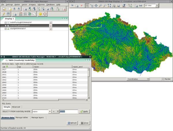
- Layer Manager – includes map layer management, integrated command-line prompt, and command output window tab.
- Map Display Window – integrates basic tools for zooming, panning, data querying, and map elements (north arrows, barscale, etc.).
- Module dialogs enable running GRASS modules.
- 2D raster analysis and 3D voxel management (volumes).
- 2D/3D Vector engine with SQL based DBMS support.
- Image processing modules.
- Vector network analysis, Linear Referencing System.
- Visualization of 2D, 3D maps and volumes.
- Interoperable with standard raster and vector formats.
- Modular architecture and scripting capabilities for batch processing.
- Supports various RDBMS (Relational database management system) and embedded databases. SQL (Structured Query Language) queries are directly passed to the underlying database system.
- Over 400 built-in analysis modules and 100 community supplied add-on modules and toolboxes can be downloaded for free.
- Python interface to the C library – create new modules in a simple way while at the same time creating powerful and fast modules.
- Can be used either as a stand-alone application or as backend for other software packages such as QGIS and R geostatistics.
Website: grass.osgeo.org
Support: Documentation, Quickstart, FAQ, Mailing Lists
Developer: Refractions Research
License: GNU Lesser General Public License
GRASS is written in C, C++, and Python. Learn C with our recommended free books and free tutorials. Learn C++ with our recommended free books and free tutorials. Learn Python with our recommended free books and free tutorials.
Related Software
| GIS: Earth Science Software | |
|---|---|
| GRASS | Geographic Resources Analysis Support System |
| Quantum GIS | User friendly Geographic Information System |
| SAGA | System for Automated Geoscientific Analyses |
| GMT | Collection of tools that allow users to manipulate data sets |
| GeoServer | Server written in Java that allows users to share and edit geospatial data |
| OpenJUMP | Geographic Information System written in Java |
| gvSIG Desktop | Powerful, user-friendly Geographic Information System |
| PostGIS | Database extender for PostgreSQL object-relational database |
| WhiteboxTools | Advanced geospatial data analysis platform |
| MapServer | System for developing web-based GIS applications |
| uDig | Spatial data viewer/editor |
Read our verdict in the software roundup.
 Explore our carefully curated directory of recommended free and open source software, covering every major software category. Explore our carefully curated directory of recommended free and open source software, covering every major software category.The directory forms part of our extensive collection of articles for Linux enthusiasts. It includes hundreds of detailed reviews, together with free and open source alternatives to proprietary software from companies such as Google, Microsoft, Apple, Adobe, IBM, Cisco, Oracle, and Autodesk. LinuxLinks also covers interesting projects worth exploring, Linux-compatible hardware, free programming books and tutorials, and much more. Know a useful free and open source Linux application that we haven’t covered? Tell us about it using our submission form. |
Please read our Comment Policy before commenting.