

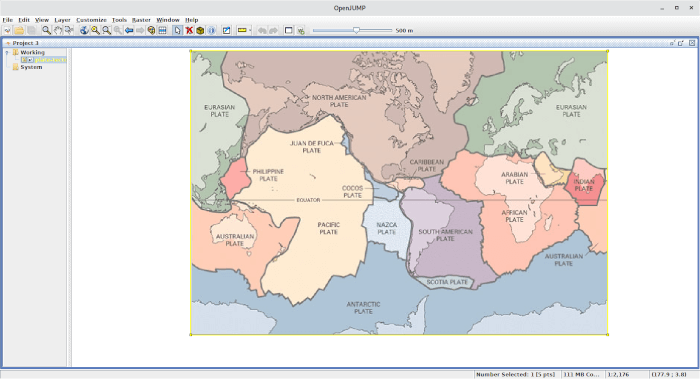
OpenJUMP is an open source Geographic Information System (GIS) written in the Java programming language. It’s the unified mapping platform.
The software is released under an open source license.
OpenJUMP is a “fork” of the JUMP “Java Unified Mapping Platform” software, developed by Vividsolutions and released in 2003.
Key Features
- Vector GIS (that can read rasters as well).
- Provides open API & PlugIn system, scripting via BeanShell and Java Python.
- Edit, save, analyze, conflate and display your GIS data.
- Strives to handle empty geometries well.
- Elaborate shortcuts, undo/redo.
- Vector formats:
- read DXF*, JML, GeoJSON, GML, SHP.
- write DXF*, JML, GeoJSON, GML, SHP, SVG*.
- Raster format read support:
- Georeferencing per world file or GeoTIFF.
- BMP, DCX, FPX, GIF, JB2, JBIG2, JPEG, PAM, PBM, PCX.
- PGM, PNG, PNM, PPM, PSD, TGA, TIFF, WBMP, XBM, XPM.
- ECW & JPEG2000 (with 32bit Java on Windows, Linux, MacOSX) incl. in Plus.
- MrSID (with oracle jre on Windows, Linux).
- Raster format write support:
- JPG, PNG
- Database access:
- Read PostGIS, ArcSDE, Oracle, MySQL, SpatialLite.
- Write PostGIS.
- Archives and compressed files:
- Read known data formats from zip, tar, tar.gz, tar.bz2 archives or gz, bz2 compressed files.
- Supports OGC standards WMS & WFS (-T), GML 2, SLD, SFS.
- Topology tools: line noder, polygonizer, planar graph,…
- Raster analysis via SEXTANTE connector.
- Attribute transfer tools (1:1 transfer, or n:1 transfer).
- Calculating length, area, centroid, buffer, convex hull,…
- Spatial and attribute query functions.
- Rotating, scaling, auto-complete polygon, cut, merge, simplify polygons and lines.
- Warping, quality assurance tools.
- Map generalization functions.
- Sophisticated print out capability.
- Internationalization support – translations are available for Chinese, Czech, Finnish, French, German, Hungarian, Italian, Japanese, Malayalam, Portuguese (Brazilian), Spanish, Tamil, and Telugu.
Website: www.openjump.org
Support: Mailing List
Developer: Jump Pilot Project Team
License: GNU General Public License version 2.0
OpenJUMP is written in Java. Learn Java with our recommended free books and free tutorials.
Related Software
| GIS: Earth Science Software | |
|---|---|
| GRASS | Geographic Resources Analysis Support System |
| Quantum GIS | User friendly Geographic Information System |
| SAGA | System for Automated Geoscientific Analyses |
| GMT | Collection of tools that allow users to manipulate data sets |
| GeoServer | Server written in Java that allows users to share and edit geospatial data |
| OpenJUMP | Geographic Information System written in Java |
| gvSIG Desktop | Powerful, user-friendly Geographic Information System |
| PostGIS | Database extender for PostgreSQL object-relational database |
| WhiteboxTools | Advanced geospatial data analysis platform |
| MapServer | System for developing web-based GIS applications |
| uDig | Spatial data viewer/editor |
Read our verdict in the software roundup.
 Explore our carefully curated directory of recommended free and open source software, covering every major software category. Explore our carefully curated directory of recommended free and open source software, covering every major software category.The directory forms part of our extensive collection of articles for Linux enthusiasts. It includes hundreds of detailed reviews, together with free and open source alternatives to proprietary software from companies such as Google, Microsoft, Apple, Adobe, IBM, Cisco, Oracle, and Autodesk. LinuxLinks also covers interesting projects worth exploring, Linux-compatible hardware, free programming books and tutorials, and much more. Know a useful free and open source Linux application that we haven’t covered? Tell us about it using our submission form. |
Please read our Comment Policy before commenting.