

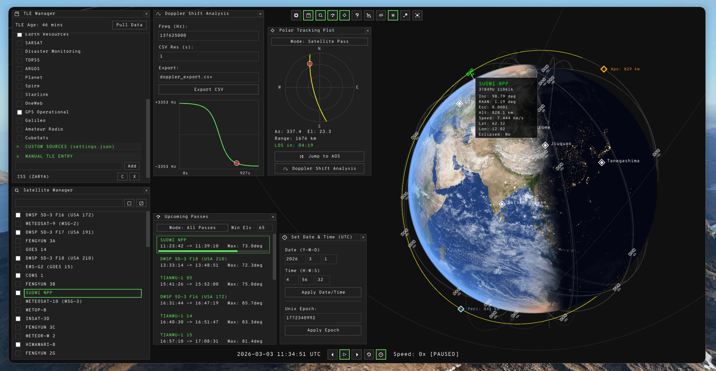
TLEscope is a satellite visualization tool designed to transform Two-Line Element (TLE) sets into intuitive, interactive data. It’s a modern and interactive 3D/2D satellite position tracker based on real TLE data.
It provides a streamlined interface for tracking the current and future positions of orbital bodies across both 3D and 2D environments.
This is free and open source software.
Key Features
- Dual-View Visualization: Seamlessly toggle between an interactive 3D orbital space and a 2D projection featuring accurate satellite ground tracks.
- Accurate Terminator Line Simulation: Easily preview sunlight conditions, in 2D and 3D.
- Coverage Analysis: Real-time rendering of Line-of-Sight (LOS) coverage areas and comprehensive orbital characteristics.
- TLE Data Integration: Efficiently load and parse TLE data for individual satellites or entire constellations.
- Customization: Deeply configurable theming and functional options to suit professional or personal preferences.
- For nerds, By nerds: TLEscope comes equipped with tools designed for RF engineers, satellite operators, and people who just want to know when to expect the next sunlit ISS pass.
- Minimal Footprint and High Performance: Developed in pure C utilizing the Raylib framework, TLEscope maintains a minimal footprint. The application provides high-performance rendering that is likely more efficient than your standard system file browser, even with hundreds or thousands of satellites on-screen.
- Cross-platform support – built for Linux and Windows.
Website: github.com/aweeri/TLEscope
Support:
Developer: Aria Horak
License: GNU Affero General Public License v3.0
TLEscope is written in C. Learn C with our recommended free books and free tutorials.
Related Software
| Satellite Tools | |
|---|---|
| Gpredict | Real-time satellite tracking and orbit prediction application |
| GNSS-SDR | Software-defined receiver for Global Navigation Satellite System signals |
| SatDump | Generic satellite data processing software |
| PreviSat | Satellite tracking software for observing purposes |
| SaVi | Simulates satellite orbits and coverage, in two and three dimensions |
| tracker | Real-time satellite tracks and orbit prediction |
| TLEscope | Satellite visualization tool |
| strf | Satellite tracking toolkit for radio observations |
| Satellite | Displays GNSS information obtained from NMEA sources |
| Ground Station | Satellite monitoring and radio communication suite |
| TermTrack | Track satellites in your terminal |
| OrbitDeck | Satellite tracking and orbital analysis software |
| OrbVis | View and propagate the full CelesTrak satellite catalog in realtime |
| Flyby | Tracks and predicts passes of satellites in Earth orbit |
| SatX Tracker | Live 3D satellite and space debris tracker |
| SatIntel | OSINT tool for satellite reconnaissance |
Read our verdict in the software roundup.
 Explore our carefully curated directory of recommended free and open source software, covering every major software category. Explore our carefully curated directory of recommended free and open source software, covering every major software category.The directory forms part of our extensive collection of articles for Linux enthusiasts. It includes hundreds of detailed reviews, together with free and open source alternatives to proprietary software from companies such as Google, Microsoft, Apple, Adobe, IBM, Cisco, Oracle, and Autodesk. LinuxLinks also covers interesting projects worth exploring, Linux-compatible hardware, free programming books and tutorials, and much more. Know a useful free and open source Linux application that we haven’t covered? Tell us about it using our submission form. |
Please read our Comment Policy before commenting.