
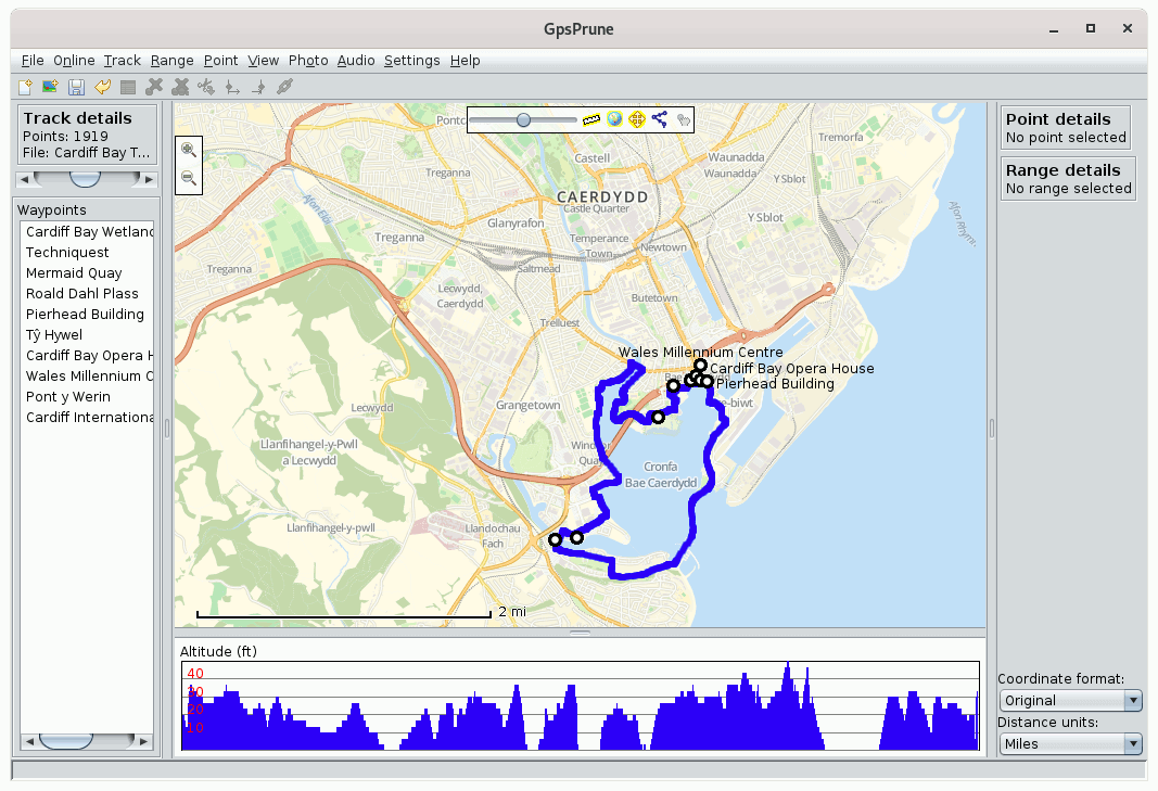
GpsPrune is a map-based application for viewing, editing and converting coordinate data from GPS systems.
It can load data from arbitrary text-based formats (for example, any tab-separated or comma-separated file) or Xml, or directly from a GPS receiver. It can display the data (as map view using openstreetmap images and as altitude profile), edit this data (for example delete points and ranges, sort waypoints, compress tracks), and save the data (in various text-based formats). It can also export data as a Gpx file, or as Kml/Kmz for import into Google Earth, or send it to a GPS receiver.
GpsPrune can display the tracks in 3d format and lets you spin the model round to look at it from various directions. You can also export the model in POV format so that you can render a nice picture using Povray. You can also create charts of altitudes or speeds. It can also load Jpegs and read their coordinates from the exif tags, and export thumbnails of these photos to Kmz format so that they appear as popups in Google Earth. If your photos don’t have coordinates yet, GpsPrune can be used to connect them (either manually or automatically using the photo timestamps) to data points, and write these coordinates into the exif tags.
This is free and open source software.
Key Features
- Loading of coordinate data from file in any text-based format, with any combination of fields and any separator, or in GPX or KML or KMZ or NMEA or GeoJSON format. Xml files can be zipped or gzipped. Files can be directly loaded from a cable-connected GPS receiver.
- Importing of huge variety of device-specific formats using GPSBabel.
- Top-down, zoomable, draggable view of data points including map images from Openstreetmap or any similar map tile server (eg OpenTopoMap, Ordnance Survey, Öpnv, …).
- Caching of map tiles to disk for faster access and offline use.
- Altitude profile view or speed profile view.
- Selection of individual points and ranges to show details.
- Deletion of duplicates and variable compression of track.
- Deletion of selected points and ranges, and reversal of ranges.
- Editing of point data, and creation of tracks and waypoints.
- Drawing of new tracks, and dragging points to reposition them.
- Re-ordering of waypoints within data set.
- Saving of data in specified text format, XML format (GPX, KML, KMZ) or sending to GPS receiver.
- Interactive 3d display of data, including map and/or terrain.
- Export to POV format for rendering of 3d model by Povray.
- Loading of photos in jpeg format with or without coordinate data in exif tags.
- Connection of photos to points, and saving of coordinates in exif tags. (requires exiftool)
- Automatic correlation of photos with track points using each photo’s timestamp.
- Inclusion of photo thumbnails in KMZ export.
- Loading, playing and correlation of audio files (such as wav, mp3, ogg) in the same way as photos.
- Generation of charts (eg altitudes, speeds) either on screen or exported to SVG file.
Launch of browser showing area in various map websites such as Google Maps or Openstreetmap. - Weather forecasts for the current location, thanks to openweathermap.org.
Geocaches near the current location, thanks to opencaching.de. - Multiple Undo.
- Internationalization support – Afrikaans (AF), Catalan (CA), Czech (CZ), DE (German), DE_ch (Swiss German), EN (English), ES (Spanish), FR (French), Hungarian (HU), IT (Italian), JA (Japanese), Korean (KO), Dutch (NL), PL (Polish), Portuguese (PT), Romanian (RO), Russian (RU), Swedish (SV) and ZH (simplified Chinese) are supported. With additional language files there is also partial support of Turkish (TR) and Ukrainian (UK), and basic (extremely limited) support of Indonesian (ID), Danish (DA), Norwegian (NO), Welsh (CY) and Farsi (FA).
Website: activityworkshop.net/software/gpsprune
Support: GitHub Code Repository
Developer: activityworkshop
License: GNU General Public License v2.0
GpsPrune is written in Java. Learn Java with our recommended free books and free tutorials.
Related Software
| Photo Geotagging Tools | |
|---|---|
| GpsPrune | View, edit and convert coordinate data from GPS systems |
| KGeoTag | Photo geotagging written in C++/Qt |
| GPS Correlate | Correlates digital images with GPS data filling EXIF fields |
| Geotag | Match date/time information from photos |
| Geotagging | Photography geotagging tool |
| GottenGeography | Photo geotagging application for the GNOME desktop environment |
Read our verdict in the software roundup.
| GPS Tools | |
|---|---|
| MOBAC | Create offline atlases for GPS handhelds and cell phone applications |
| GPXSee | GPS log file viewer and analyzer |
| Traccar | GPS Tracking Platform |
| gpsd | GPS service daemon |
| Viking | GPS data editor, analyzer and viewer |
| GPSBabel | GPS file conversion plus transfer to/from GPS units |
| GpsPrune | View, edit, and convert coordinate data from GPS systems |
| ZombieTrackerGPS | Fitness and GPS track manager designed for KDE |
| QMapShack | GPS mapping (GeoTiff and vector) and GPSr management |
| Navit | Car navigation system with routing engine |
| GPS Correlate | Correlates digital images with GPS data filling EXIF fields |
| Open Cache Manager | Easy to use program for managing your geocaches |
| FoxtrotGPS | GPS/GIS application designed for small screens |
| Satellite | Displays GNSS information obtained from NMEA sources |
| Geotagging | Photography geotagging tool |
| AAT Activity Tracker | Tracking sportive activities, with an emphasis on cycling |
Read our verdict in the software roundup.
 Explore our comprehensive directory of recommended free and open source software. Our carefully curated collection spans every major software category. Explore our comprehensive directory of recommended free and open source software. Our carefully curated collection spans every major software category.This directory is part of our ongoing series of informative articles for Linux enthusiasts. It features hundreds of detailed reviews, along with open source alternatives to proprietary solutions from major corporations such as Google, Microsoft, Apple, Adobe, IBM, Cisco, Oracle, and Autodesk. You’ll also find interesting projects to try, hardware coverage, free programming books and tutorials, and much more. Discovered a useful open source Linux program that we haven’t covered yet? Let us know by completing this form. |