
openrouteservice is a Java-based routing backend for building route planning and spatial analysis services from OpenStreetMap data.
It is designed for self-hosting and provides an API that can be used in custom applications, internal services, and research workflows that need route calculation, reachability analysis, and transport-aware spatial processing.
This is free and open source software.
Key Features
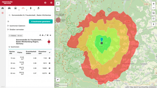
- Provides dedicated API endpoints for directions, isochrones, matrix calculations, snapping, and graph export.
- Supports self-hosting, with Docker recommended as the simplest deployment method.
- Can be used for route planning and accessibility analysis across multiple transport profiles, including car, heavy vehicle, cycling, walking, hiking, and wheelchair scenarios.
- Includes health and status endpoints for locally hosted instances.
- Uses OpenStreetMap data as the foundation for its routing and spatial services.
Website: openrouteservice.org
Support:
Developer: GIScience Research Group and HeiGIT
License: GNU General Public License v3.0 and GNU Lesser General Public License v3.0
openrouteservice is written in Java. Learn Java with our recommended free books and free tutorials.
Related Software
| Travel Planners | |
|---|---|
| AdventureLog | Self-hostable travel tracker and trip planner |
| OpenTripPlanner | Multi-modal trip planner |
| KDE Itinerary | Digital travel assistant |
| GraphHopper | Fast, memory-efficient routing engine |
| Openrouteservice | Build route planning and spatial analysis services |
| KTrip | Public transport navigator |
| Railway | Look up travel information |
Read our verdict in the software roundup.
 Explore our comprehensive directory of recommended free and open source software. Our carefully curated collection spans every major software category. Explore our comprehensive directory of recommended free and open source software. Our carefully curated collection spans every major software category.This directory is part of our ongoing series of informative articles for Linux enthusiasts. It features hundreds of detailed reviews, along with open source alternatives to proprietary solutions from major corporations such as Google, Microsoft, Apple, Adobe, IBM, Cisco, Oracle, and Autodesk. You’ll also find interesting projects to try, hardware coverage, free programming books and tutorials, and much more. Discovered a useful open source Linux program that we haven’t covered yet? Let us know by completing this form. |