

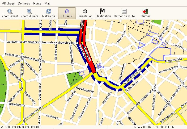
Navit is a car navigation system with its own routing engine. It is designed to work without depending on a permanently available network connection, using locally stored vector maps for map display, searching and route calculation.
Its modular architecture separates map handling, position input, routing and user-interface components. Navit can obtain a position directly from a GPS receiver, through gpsd or from supported platform location services. GTK and SDL interfaces are available and are designed to be usable on touchscreens as well as conventional computers.
This is free and open source software.
Key Features
- Uses locally stored vector maps for navigation and route calculation.
- Supports OpenStreetMap data for map display and routing.
- Can display several map sources together within the same navigation setup.
- Receives location data directly from a file or device, from a local or remote gpsd instance, or from supported mobile location services.
- Includes its own routing engine for calculating routes to a destination.
- Uses a Lifelong Planning A* based routing approach to calculate estimated travel costs through the road network.
- Experimental traffic support can recalculate affected portions of a route when traffic conditions change.
- Generates turn-by-turn directions and can provide spoken navigation instructions.
- Supports a large number of interface and spoken-navigation languages.
- Displays points of interest and provides destination searching using supported map data.
- GTK and SDL graphical interfaces support touchscreen installations such as in-car computers.
- Can obtain experimental position information from a UDP source for applications such as friend tracking.
- Cross-platform support – runs on Linux, macOS, and Windows.
Website: github.com/navit-gps/navit
Support:
Developer: Navit contributors
License: GNU General Public License v2.0
Navit is written in C. Learn C with our recommended free books and free tutorials.
Related Software
| GPS Tools | |
|---|---|
| MOBAC | Create offline atlases for GPS handhelds and cell phone applications |
| GPXSee | GPS log file viewer and analyzer |
| Traccar | GPS Tracking Platform |
| gpsd | GPS service daemon |
| Viking | GPS data editor, analyzer and viewer |
| GPSBabel | GPS file conversion plus transfer to/from GPS units |
| GpsPrune | View, edit, and convert coordinate data from GPS systems |
| ZombieTrackerGPS | Fitness and GPS track manager designed for KDE |
| QMapShack | GPS mapping (GeoTiff and vector) and GPSr management |
| Navit | Car navigation system with routing engine |
| GPS Correlate | Correlates digital images with GPS data filling EXIF fields |
| Satellite | Displays GNSS information obtained from NMEA sources |
| PyGPSClient | Graphical tool for GNSS receiver testing, diagnostics and configuration |
| OpenCPN | Ship-borne GUI navigation |
| gpx.studio | GPX editor for creating, modifying and planning GPS routes |
| Geotagging | Photography geotagging tool |
| AAT Activity Tracker | Tracking sportive activities, with an emphasis on cycling |
Read our verdict in the software roundup.
 Explore our carefully curated directory of recommended free and open source software, covering every major software category. The directory forms part of our extensive collection of articles for Linux enthusiasts. It includes hundreds of detailed reviews, together with free and open source alternatives to proprietary software from companies such as Google, Microsoft, Apple, Adobe, IBM, Cisco, Oracle, and Autodesk. LinuxLinks also covers interesting projects worth exploring, Linux-compatible hardware, free programming books and tutorials, and much more. Know a useful free and open source Linux application that we haven’t covered? Tell us about it using our submission form. |
Please read our Comment Policy before commenting.