Survex is a software suite to process, view, and print cave survey data. Survex is cross-platform running under Linux, Unix, Mac OS X, Microsoft Windows). It can deal with extremely large and complex datasets and can read survey data from many sources.
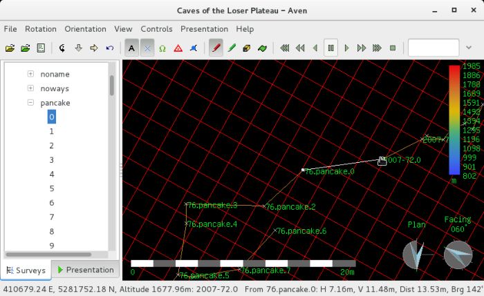
Survex is capable of processing extremely complex caves very quickly and has a very effective, real-time cave viewer which allows you to rotate, zoom, and pan the cave using mouse or keyboard.
Survex includes English, French, German, Portuguese, Catalan, Spanish, Slovak, and Romanian internationalisations.
Survex is used by many survey projects around the world, such as the Ogof Draenen survey, the Easegill resurvey project, Austria – Dachstein, the OFD survey, the OUCC Picos expeditions, and the Hong Meigui China expeditions.
Key Features
- Fast cave viewer with fast redraw and bank-switching techniques.
- Hierarchical survey station naming.
- Fast processing of survey data in a wide range of formats, aided by sophisticated network simplification techniques.
- Data Processing:
- Cave complexity limited only by available memory.
- Include files allow projects for survey data management.
- No restrictions on the order survey data.
- Support for a wide range of data styles, including “interleaved data”, backsights, underwater surveys performed with a depth gauge, and unsurveyed visual connections.
- Network reduction with loop closure errors distributed by least squares. Standard errors and closure errors are reported. There’s also an experimental gross error (blunder) detector.
- Data can be partially processed, loops closed, and then more data processed which will not move the existing stations. This is useful for adding a loop to an existing map without redrawing the whole thing.
- All instruments (e.g. tape, compass, clino, topofil, depth gauge) have optional scale and zero corrections.
- Special handling for plumbed legs (where the clino correction doesn’t apply).
- Magnetic deviation separately specifiable to compass calibration (useful for survey projects lasting many years).
- Support for most input units: metres, feet, degrees, mils, grads, minutes, and also user specifiable units. Percent gradient is also supported.
- Each measurement can have its Standard Deviation specified separately (for specifying the ‘grade’ of a section, giving special treatment to an odd or suspicious measurement, or feeding in measurements derived from techniques such as radiolocation).
- Internationalisation support – translations supplied for English, French, German, Spanish, Catalan, Portuguese, Italian, Slovak, Romanian, and US English.
- Support for printing using native drivers for PostScript, ESC/P (Epson, IBM Proprinter, Canon BJs and compatibles), PCL (HP Laserjets, Deskjets and compatibles), and HPGL (HP pen plotters and compatibles).
- Colour printing supported when using the included Postscript driver
Website: survex.com
Support: Documentation
Developer: Olly Betts, Mark Shinwell, Wookey, and many contributors
License: GNU General Public License v2.0
Survex is written in C++ and C. Learn C++ with our recommended free books and free tutorials. Learn C with our recommended free books and free tutorials.
Related Software
| Earth Science Software | |
|---|---|
| GRASS | Geographic Resources Analysis Support System |
| Quantum GIS | User friendly Geographic Information System |
| Survex | Cave surveying and mapping software |
| SAGA | System for Automated Geoscientific Analyses |
| GPlates | Interactive visualization of plate-tectonics |
| GMT | Collection of tools that allow users to manipulate data sets |
| Therion | Cave surveying - 2D and 3D drawing software |
| GeoServer | Server written in Java that allows users to share and edit geospatial data |
| OpenJUMP | Geographic Information System written in Java |
| GrADS | Grid Analysis and Display System for earth science data |
| gvSIG Desktop | Powerful, user-friendly Geographic Information System |
| PostGIS | Database extender for PostgreSQL object-relational database |
| WhiteboxTools | Advanced geospatial data analysis platform |
| ObsPy | Framework to process, analyse, and visualise seismological data |
| ncview | Visual browser for NetCDF format files |
| MapServer | System for developing web-based GIS applications |
| OpenDrift | Framework for ocean trajectory modelling |
| MetPy | Read, visualize and perform calculations with weather data |
| uDig | Spatial data viewer/editor |
| OpenSees | Open System for Earthquake Engineering Simulation |
| Grock | Displays a geological map of the UK |
Read our verdict in the software roundup.
 Explore our comprehensive directory of recommended free and open source software. Our carefully curated collection spans every major software category. Explore our comprehensive directory of recommended free and open source software. Our carefully curated collection spans every major software category.This directory is part of our ongoing series of informative articles for Linux enthusiasts. It features hundreds of detailed reviews, along with open source alternatives to proprietary solutions from major corporations such as Google, Microsoft, Apple, Adobe, IBM, Cisco, Oracle, and Autodesk. You’ll also find interesting projects to try, hardware coverage, free programming books and tutorials, and much more. Discovered a useful open source Linux program that we haven’t covered yet? Let us know by completing this form. |