

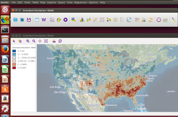
GeoDa is a graphical application for exploratory spatial data analysis, geovisualization, spatial autocorrelation and spatial modelling. It is designed to help users investigate spatial patterns and relationships without requiring a programming environment.
The software combines linked maps and statistical graphics with spatial statistics, clustering and regression tools. Views are linked, so selections made in a map or chart are reflected across other open views, making it easier to explore relationships between geography and data.
This is free and open source software.
Key Features
- Exploratory spatial data analysis through linked maps, charts and statistical views.
- Global and local spatial autocorrelation statistics including Moran’s I and local indicators of spatial association.
- Local Geary statistics and local join count analysis for categorical data.
- Differential Moran’s I for examining spatial clustering in changes over time.
- Spatial regression including spatial lag and spatial error models.
- Ordinary least squares regression with diagnostic statistics.
- Spatially constrained clustering methods including REDCAP, SKATER, max-p and spectral clustering.
- Non-spatial clustering and dimensionality-reduction techniques including k-means, hierarchical clustering and principal component analysis.
- HDBSCAN clustering.
- Multi-layer mapping for adding contextual geographic layers to analytical maps.
- Time Editor and Time Player for exploring spatial and temporal patterns across linked views.
- Basemap support for projected spatial data.
- Histogram, box plot, scatter plot, scatter plot matrix, bubble chart, parallel coordinate plot and conditional plots.
- Cartograms and thematic maps with configurable classifications.
- Nonparametric spatial correlogram for investigating distance thresholds of spatial correlation.
- Spatial weights creation and management.
- Supports shapefiles, GeoJSON, geodatabases, MapInfo, GML, KML and other vector formats supported through GDAL.
- Imports tabular data including CSV, DBF, XLS and ODS files and can convert coordinates to spatial datasets.
- Exports selected observations and converts between supported spatial data formats.
Website: geodacenter.github.io
Support:
Developer: Dr. Luc Anselin and his team
License: GNU General Public License v3.0
GeoDa is written in C++. Learn C++ with our recommended free books and free tutorials.
Related Software
| Econometric Software | |
|---|---|
| R | Statistical computation and graphics system |
| gretl | Regression, Econometric and Time-Series Library |
| Grocer | Econometric toolbox for Scilab, software similar to Gauss and Matlab |
| GeoDa | Exploratory data analysis and spatial regression |
| gbutils | Set of command line utilities for the manipulation and statistical analysis of data |
| Draco | Econometrics and statistics package |
| Minsky | System dynamics program with additional features for economics |
| Dynare | Software platform for handling a wide range of economic models |
Read our verdict in the software roundup.
 LinuxLinks helps you discover the best free and open source software for Linux. Explore our extensive collection of recommended applications, including alternatives to popular proprietary software. We also publish software reviews, Linux tutorials, hardware reviews, free programming books and articles covering the wider open source community. Browse our Linux resources to discover more. Know a useful free and open source Linux application we haven't covered? Suggest a program for inclusion. Has your software been featured on LinuxLinks? Display one of our Featured on LinuxLinks badges on your website or GitHub README. |
Please read our Comment Policy before commenting.